What was once a difficult and lengthy job has now become something out of a futuristic 80’s movie. Where land surveyors originally had to trek over wild land in order to map the topography of a specified site, they’re now being replaced by UAVs.
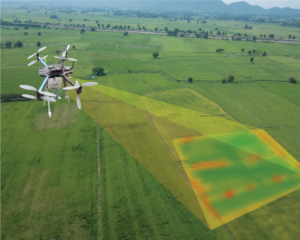
Unmanned Aerial Vehicles (UAVs), commonly known as drones, have revolutionized many industries in recent years. One of the industries that have benefited significantly from drone technology is surveying. In this blog post, we will dive into how UAV surveys have made the surveying process faster, more efficient, more accurate, and what type of drone surveys are available for varying survey needs.
One of the most significant benefits of using drones for surveying is the speed at which they can collect data. Traditional surveying methods can be time-consuming and can take days or even weeks to complete, depending on the size of the area to be surveyed. With UAV surveys, data can be collected in a matter of hours, reducing the overall surveying time significantly.
Using UAVs for surveying is also cost-effective. Traditional surveying methods require extensive equipment, including total stations and GPS receivers, which can be expensive to purchase and maintain. UAVs, on the other hand, are relatively inexpensive and require minimal maintenance, making them a more cost-effective option.
UAVs can collect high-quality data that is accurate and detailed. They can capture aerial images, video footage, and 3D models of the surveyed area, providing a comprehensive view of the site. This data can then be processed and analyzed using specialized software, providing accurate measurements and detailed visualizations.
Using drones for surveying can also improve safety for land surveyors. Traditional surveying methods may require surveyors to access hazardous areas or work at height, which can be dangerous. With UAV surveys, the drone can capture data from a safe distance, reducing the risk of accidents and injuries.
Drones are versatile and can be used in a variety of surveying applications, including topographic surveys, volumetric calculations, and asset inspections. They can be used in a range of industries, from construction and mining to agriculture and environmental management.
Because drones are increasingly being used for various surveying and mapping applications, there are now several types of surveys that can be conducted using one.
Photogrammetry: UAVs equipped with high-resolution cameras can capture aerial images that can be used to create 3D models and digital surface models. Photogrammetry is widely used in many industries, including land surveying, agriculture, mining, and construction.
Videography: One of the most common ways drones are seen/used is through videography. Whether real estate, marketing, or a technological use like land surveying, drones are creating a huge imprint on the industry. In land surveying, they’re often used for capturing high-quality video footage of construction sites, buildings, and other structures, providing a detailed view of the site and helping to identify potential issues or hazards.
LiDAR (Light Detection and Ranging): LiDAR-equipped UAVs use laser sensors to collect data points that can be used to create highly accurate 3D maps. This technology is commonly used in land surveying, forestry, and urban planning.
Thermal Imaging: UAVs equipped with thermal cameras can capture thermal images, which can be used to identify temperature differences and create thermal maps. This technology is useful in applications such as monitoring wildfires, inspecting buildings for energy efficiency, and detecting wildlife.
Magnetometry: Drones equipped with magnetometers can detect variations in magnetic fields and create maps that provide information used to locate buried objects such as pipes, cables, and buried rock formations. This technique is based on the fact that different materials have different magnetic properties, and these properties can be detected by measuring changes in the Earth’s magnetic field.
Hyperspectral Imaging: Hyperspectral cameras on UAVs are used to gather detailed information about the Earth’s surface, such as the composition of soils and vegetation, and to monitor changes in the environment. This can be useful for surveying agriculture, because it gives detailed maps of vegetation, water quality, and other environmental factors.
Gas Detection: UAVs equipped with gas sensors can detect and map emissions of gasses such as methane, carbon dioxide, and volatile organic compounds. This technology is useful in environmental monitoring, oil and gas exploration, and industrial inspections.
Overall, drone surveys offer a cost-effective, safe, versatile, and efficient way to gather data for a variety of applications. At Arc Surveys, we utilize the latest technology, including drones, to provide accurate and varying surveying services to our clients.
Arc Surveys
Have any further questions regarding UAV Surveys? Give us a call (780-800-1260) or drop us an email at [email protected]. We’ll help you get a better understanding on how to get the best information towards completing your next survey project.